Why plantations need Geospatial Technology
The global geospatial imagery analytics market is estimated to reach $42.2 billion by 2027. The demand for the market is increasing due to the rise in the adoption of wireless devices and location-based sensors, allowing businesses to collect location-specific data to improve their business operations.
What is Geospatial Technology?
Geographic information systems (GIS) began in the 1960 and has since evolved to provide data for industries ranging from the defence & security, utility companies, engineers, and urban planners just to name a few. Geospatial data are also useful for biodiversity conservation, agriculture monitoring and even humanitarian relief. The main benefit it provides is visualisation and analysis of geographic data. Some of the common geospatial technologies are remote sensing, geographic information system (GIS) and global positioning system (GPS). Both remote sensing and GPS enables information to be collected about Earth’s surface. While GIS is a mapping tool that provides organizing and analysing of geographically referenced information. A GIS map can contain unlimited amounts of geospatial data which will help users better understand trends and patterns of a location.
Why Mapping Technology Is Beneficial for Palm Oil Industry
When it comes to palm oil plantation management, visibility is a crucial element to help industry players thrive. This is especially important in light of the current challenges such as labour shortages, price fluctuations, and inefficient crop harvesting.
The Malaysian palm oil industry is currently facing severe labour shortages with output expected to drop, and opportunity losses is estimated to reach RM20bil by year end. “The total crop losses for the Malaysian palm oil industry this year will translate into just over six million metric tonnes of fresh fruit bunches, equal to over one million tonnes of vegetable oil rotting in the fields,” said Bek-Nielsen, a council member of the Malaysian Palm Oil Association.
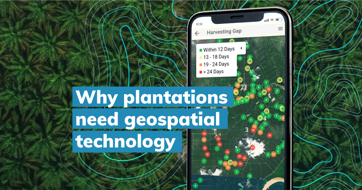
Evidently, the labour shortage issue possesses a great challenge, however it can be mitigated by utilising the right mapping tools. Geospatial technologies can provide near real-time insights for palm oil plantations to help make better informed decision. This will be especially helpful when it comes to time-sensitive decisions such as when to harvest palm oil fruits. Quarto’s mapping technology can assist planters in identifying areas which needs immediate harvesting. Additionally, geospatial technologies play an important role in the agriculture industry by improving production, reducing costs, and enabling planters to manage land resources effectively. Quarto offers precise identification of harvesting intervals block-by-block with accurate GPS coordinates. This vital information will assist to minimise fruit spoilage and detect areas that need prompt action, which is important when resources such as labour is scarce.
In turn, estate managers can better allocate their existing resources with the help of geospatial technologies. Spatial information gathered from imaging technology such as drones can also help in identifying patterns and support the decision-making process when it comes to land use and determining yield patterns. Drones are helpful to obtain in-field data at difficult to access locations such as to map difficult terrains. Manually obtaining data may also risk inaccuracies while mapping technology can help to effectively identify divisional and block demarcations. Plantation management requires accurate information of estate divisions. Budgets and production estimates can then be better determined based on division and block areas with accurate data.
These easy-to-recognize visual patterns and pictures derived thanks to geospatial technologies will show insights that can be missed if a manual process is utilised, for example a large spreadsheet with manually input data.
Managing Plantations with Mapping Technology
Geospatial technology can lead to greater efficiencies and therefore greater profitability. It should be noted that not all mapping technologies are equipped to handle large data sets. Quarto’s powerful cloud-based platform is capable to support large data sets. Furthermore, Quarto is designed to be adaptable, and can support hosting of other information to deliver a comprehensive overview of estates.
Moreover, geospatial solutions can assist in uncovering critical business information that will help to efficiently manage operations and identify new opportunities. Quarto can also utilise geographical data and cross analyse it with FFB yield to assess if there are any discrepancies against labour or even fertilisation. Doing so will help in determining if labour is efficiently managed, and fertilisation strategies can be further optimised to maximize yields. Moreover, mapping technology can help in identifying blocks that are under performing. Spatial data will allow management to drill into any geographical area to analyse and identify patterns.
Quarto’s all-in-one platform will also ease the process of streamlining operations, for efficient palm oil plantation management. Estate managers and field managers can share information between teams while getting latest in-field updates without having to wait for manual reporting.
Future-proofing palm oil plantations
Future proof your plantation business and increase resilience by adopting the relevant geospatial enterprise solutions. Contact us to know how you can leverage the power of mapping technology to transform your palm oil plantation management today.